Overview
The Database for Imaging Multi-spectral Instruments and Tools for Radiometric Intercomparison (DIMITRI) manages L1 data from various medium resolution imagers over terrestrial targets chosen for their radiometric properties and/or the availability of in-situ radiometric measurements. DIMITRI comes with a suite of tools that allow comparison of the L1 data originating from various sensors in the database at Top Of the Atmosphere (TOA) level.
DIMITRI was initially prototyped at ESA/ESTEC. It is currently maintained by ESA, ARGANS and MAGELLIUM.
You can request the DIMITRI software below.
Software Tools
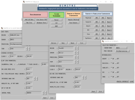
DIMITRI has a user-friendly interface for reading the database and making intercomparisons over these sites based on user-selection of a reference sensor, against which other sensors are compared. The software package contains a suite of IDL routines (it can be run with a free IDL run time license). DIMITRI can be used for the intercomparison of TOA radiance and reflectance values within the 400nm – 4μm wavelength range; this is generally known as Level 1b Earth Observation (EO) satellite data. DIMITRI offers the following capabilities and functionalities:
- Product reader and data extraction routines
- Comparison of satellite data based on user defined cloud screening parameters as well as temporal, spatial and geometric matching
- Extracted Top of Atmosphere (TOA) reflectance time series and variability
- Updated radiometric recalibration & bidirectional reflectance distribution function (BRDF) modelling
- Rayleigh and Sun glint TOA intercomparison with modelled data
- L1b auxiliary data extraction (e.g. ozone, water vapour)
- Quicklook generation with Region of Interest (ROI) overlays
- Automated & manual cloud screening of new products
- CSV outputs and improved JPGs
- Interactive Human-Machine Interface (HMI) and Data visualisation tool
- Absolute angular matching criteria
- Instrument spectral response comparison tool
More information can be found in the Software User Manual.

Screenshots of the DIMITRI interface
References
Sterckx, S., Adriaensen, S.; Dierckx, W.; Bouvet, M., 2016.PROBA-V in-flight radiometric performance : Status after 3 years in orbit, Living Planet Symposium 2016, Prague.
Bouvet, M., 2006. Intercomparisons of imaging spectrometers over the Salar de Uyuni (Bolivia). Proceedings of the Second Working Meeting on MERIS and AATSR Calibration and Geophysical Validation (MAVT-2006), 20-24 March 2006, ESRIN, Frascati, Italy (ESA SP-615, July 2006).VIEW
Bouvet, M., Goryl, P., Chander, G., Santer, R., & Saunier, S., 2007. Preliminary radiometric calibration assessment of ALOS AVNIR-2. Proceeding of the IGARSS 2007. VIEW
Bouvet, M., Ramoino, F., 2010. Radiometric intercomparison of AATSR, MERIS, and Aqua MODIS over Dome Concordia (Antarctica). Can. J. Remote Sensing, Vol. 36, No. 5, pp. 464-473. VIEW
Bouvet, M., 2014. Radiometric comparison of multispectral imagers over a pseudo-invariant calibration site using a reference radiometric model. Remote Sensing of Environment, No. 140, pp. 141-154. VIEW
Algorithm Theoretical Baseline Documents
Rayleigh Scattering Methodology for Vicarious Calibration VIEW
Radiometric monitoring using oceanic sites VIEW
Interband Vicarious Calibration over Sun glint VIEW
Band-to-band intercalibration using the sun glint over ocean VIEW
Sensor to simulation intercomparison over Desert-PICS VIEW
Radiometry monitoring using Desert sites VIEW
Sensor to simulation intercomparison over Snow-PICS VIEW
Interband Vicarious Calibration over Deep Convective Cloud VIEW
Radiometry monitoring over Deep Convective Cloud VIEW
Miscelaneous
Private Section Access
Last News
30/01/2024
DIMITRI V4.7.0 is available now. The additions to this version are as follows:
- Vicarious Calibration methods over DCC and SNOW
- Synthesis-Plots unit of the calibration methods
- Integration of installation testing unit
- Integration of Sentinel-2a/b/c/d / MSI
- Integration of Sentinel-3a/b/c/d / OLCI
- Integration of Sentinel-3a/b/c/d / SLSTR
- Integration of Landsat-8/9 / OLI
- Correction of bugs
Sites, Location & Surface Type
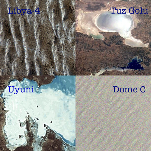
DIMITRI employs user-defined sites for intercomparison purposes. Nonetheless, the following sites are pre-defined in the tool:
| Algeria-3 | North Africa | Desert |
| Algeria-5 | North Africa | Desert |
| Amazon | South America | Vegetation |
| Boussole | Ligurian Sea | Ocean |
| Dome-C | Antarctica | Ice/Snow |
| Libya-1 | North Africa | Desert |
| Libya-4 | North Africa | Desert |
| Mauritania-1 | North Africa | Desert |
| Mauritania-2 | North Africa | Desert |
| North East Pacific | Pacific Ocean | Ocean |
| North West Atlantic | Atlantic Ocean | Ocean |
| North West Pacific | Pacific Ocean | Ocean |
| South Indian Ocean | Indian Ocean | Ocean |
| South Pacific Gyre | Pacific Ocean | Ocean |
| South West Atlantic | Atlantic Ocean | Ocean |
| East Mediterranean | Mediterranean Sea | Ocean |
| Maldives | Maldives Zone | Cloud |
| Indonesia | Indonesian Zone | Cloud |
| RadCalNet | World wide | Desert/Vegetation |
| Tuz Golu | Turkey | Salt lake |
| Uyuni | Bolivia | Salt lake |

Radiometric Target Sites included in DIMITRI
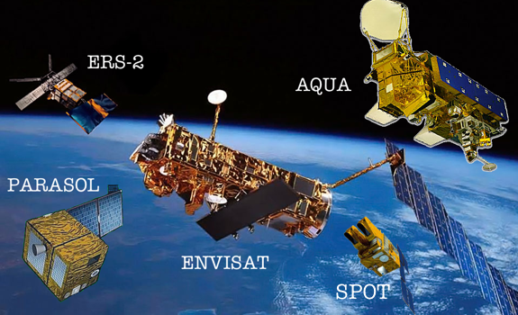
Multi-spectral Instruments
| ATSR2 | ERS-2 | ESA |
| AATSR | Envisat | ESA |
| MERIS | Envisat | ESA |
| VEGETATION | PROBA-V | ESA |
| MSI | Sentinel-2 | ESA |
| OLCI | Sentinel-3 | ESA |
| SLSTR | Sentinel-3 | ESA |
| MODIS | Aqua | NASA |
| OLI | Landsat-8 | NASA |
| POLDER-3 | PARASOL | CNES |
| VEGETATION-2 | SPOT | CNES |

Platforms carrying instruments included in DIMITRI
Accessing to DIMITRI
DIMITRI software is accessible under request, For that purpose, please, show your interest in the e-mail address available below, by clicking in the button.
Additional downloads
DIMITRI software requires further data to properly work. Apart from the tool (available under request), the following files are needed:
| ERA/Interim Climatology data (last update: 19/05/2016 - 21 GB) |
| DOWNLOAD |
| Quicklook for TDS/DB links (last update: 14/12/2023 - 73 KB) |
| DOWNLOAD |
| AUX data files (last update: 13/06/2023 - ~2 GB) |
| DOWNLOAD |
| LibRadTran 1.7 ( 60 MB) |
| DOWNLOAD |
| OPAC Library for LibRadTran ( 835 MB) |
| DOWNLOAD |
Note that LibRadTran installation has external dependencies to be considered. Users shall go to this website for further details.


